The guesthouse in Egilsstadr had been more than comfortable, with views to die for. It was an early morning start to the day, as usual. Within a few kilometers I came across the Jokulsa River cutting through a rift with a bridge spanning it.
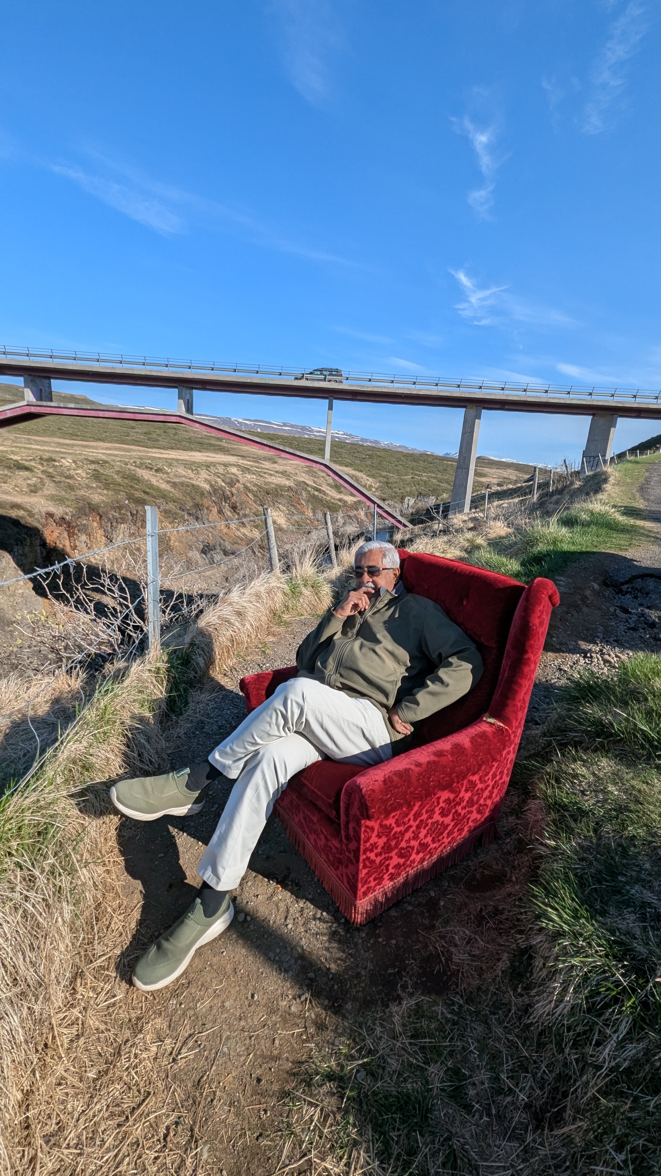
The Jokulsa is the largest river in North Iceland. It's catchment area, 7380 sq km, is the largest in the country and part of it is under a glacier. The river is 206 km long. There is a viewing area and a couple of picnic tables at two levels on the Egilsstadr end. Even a red single seater sofa was placed there for photo ops. The clean air and the calmness surrounding the area, save the musical flow of Jokulsa, made me forget that I have a long way to go for the day. Moreover, this day was one where Jokulsa would travel with me for the most of it.

About 50 km from Egilsstadr is the parking lot for the Ryjukandi Waterfall. Iceland is waterfall country and there are many that I went to during the Nordic Escapade. The Rjyukandi waterfall is a pretty one that is reached by a short hike up a steep slope. Though not many people stop by the site, it captivated me and created a majestic experience early in the morning. The Rjyukandi Waterfall is fed by the Jokulsa river. The waterfall has two main drops and they and make a picturesque sight. The total height of the waterfall is 305 feet. An upstream dam, part of the largest power plants in the country, has considerably reduced the power of this waterfall over the years.

From the lovely experience of the Ryjukandi Waterfall I directed my sights to the Studlagil Canyon, which is one of the most stunning and interesting natural wonders in Iceland. Turning off from the ring road, it is a 20 km drive to the west side of the canyon, of which nearly 10 km are unpaved roads. The viewing on the west side of the canyon, interestingly, is located on the private Grund farm. The farm used to raise sheep in the past. From the parking lot, which is paid, the observation platform is reached through a few flights of steel staircase, very well maintained.
Towering hexagonal columns of basalt line the walls of the Studlagil Canyon, contrasting with the glacial river that flows through. The Canyon remained largely hidden until 2009, when the construction of a hydroelectric plant lowered the water level, revealing the most extensive collection of basalt columns in Iceland.
It is said that the east side of the canyon provides the best experience. I went to the west as the east side calls for a 2.5-mile hike from designated parking areas. I didn't have the stomach for such a long walk. The river running through the canyon displays vibrant turquoise hues from March to July, changing to a silty gray later in summer as glacial melt increases.

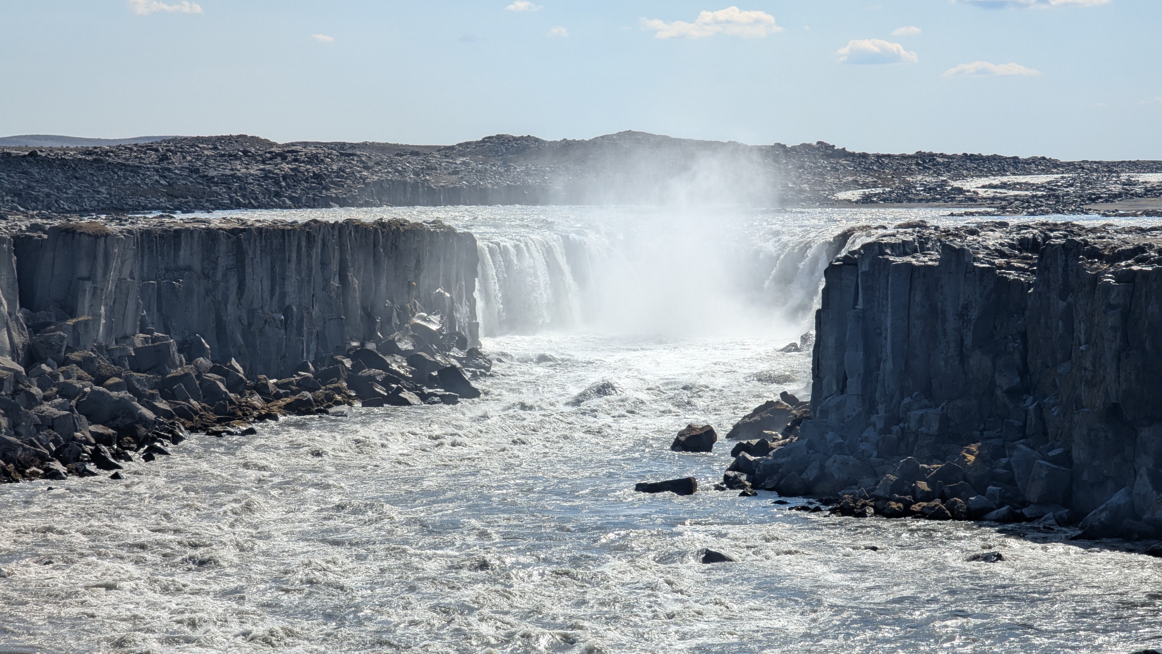
My next stop on the itinerary was about 130 km away from the stunning canyon. The Detrifoss falls is the second largest waterfall in Iceland in terms of volume discharge having an average water flow of 193 cubic metres per second. The waterfall is 100 metres wide with a drop of 44 metres down to the canyon Jokulsargljufur. From the parking lot one can take the easy walk over a black sand path studded with massive lave boulders to the viewing platform as well as to the views of by the falls from up close. I went to the latter and had magnificent experience of the powerful falls embellished by three clear rainbows. It was magical, to say the least. The sediment-rich runoff colours the Dettifloss water a greyish white.

The Selfoss waterfall is under a kilometer walk from the Dettifoss waterfall; a case of buy one, get one free! Selfoss It is not to be confused with the pretty town of the same name in the south of Iceland. Selfoss is much wider than it is tall; its height is eleven metres, while its width is around 100 metres. A long distance view of the Selfoss waterfall reminded me of the Niagara waterfall because of its horseshoe shape and the spray rising from it. I could not get close to the waterfall as the approach to it had been cordoned off, posssibly because of the slippery rocks. The waterfall is fed by the Jokulsa river as is Dettifoss.
By the time I got back from the almost three kilometre walk to the twin waterfalls, the intensity of the sun had reached such levels that I was sweating, for the first time since arriving in Iceland. The next few sights to explore were closer to Myvatn, my town for the night halt.
The Krafla is a caldera, part of a greater volcanic system of the same name, and is one of the country’s most explosive volcanoes, having gone off approximately 29 times since the country was first settled. The crater of Krafla’s caldera is about ten kilometers. The drive to the Víti crater, which is located in this fissure zone, is through the Krafla geothermal power plant which opened in 1978. The Krafla Geothermal Station utilises geothermal steam from 18 boreholes to drive two 30 MW turbines.

The Viti crater is famed for the green lake. The name Viti means 'hell', referring to its violent past. This Víti crater in Krafla was formed in 1724 by a massive eruption of the Krafla volcanic region. The eruptions lasted, in its entirety, for five years, and was called the Mývatn Fires. Jets of lava shooting up in the sky were said to have been visible from the South Coast of Iceland. The fires caused havoc in Iceland as well as in Europe, bringing about crop failures, death of livestock, flora and fauna, as well as humans. One can walk over the edge of the Viti crater taking in the magnificence of the green lake that is still partially covered in snow.

Back to the ring road from the Krafla crater and a short distance away is Hverir, a geothermal area that offers a captivating display of unique physical features that testify to earth's dynamic geology. One of the most striking features of Hverir is its abundance of fumaroles, or steam vents, releasing columns of hot steam into the air. These vents result from the intense geothermal activity beneath the surface, where magma heats groundwater, causing it to rise and escape through fissures in the Earth's crust.

Accompanying the fumaroles are the bubbling mud pools, which create a mesmerizing spectacle as they churn and belch mud and gasses from deep within the Earth. These mud pots are formed when acidic gasses interact with the surrounding rocks, breaking them into thick mud. The 'stink' caused by the belching mudpots is too much for most visitors; some of them run away clutching a towel to their noses and some others just stay away from getting close to them. Overall, I felt as if I was on another planet as I walked around the geothermal area.

I was booked to stay in the Skutuskadir guesthouse in Myvatn, which was almost on the Lake by the same name. Micheal, the young man from Poland who was looking after the reception duties, showed me to my room, told me about the breakfast timing and told me about places I could visit nearby. First, I had to fill up fuel. There was an Orkan outlet just next door. The rental company had an arrangement with Olis, but there was no outlet in Myvatn. To my horror the automated fuel pump 'ate up' 30,000 ISK against a billing of less than 10,000! Micheal told me that it was just a deposit, and the rest would be refunded. I am anxiously waiting for the refund of the balance amount.
I drove to the N1 self-service fuel station where I could wash my car for free. The car was covered with a thick layer of dust and grease over the past few days on the road. After the shower the car looked set for the last few days around the north of Iceland.
On the way back I dropped in at Hofdi, the conservation area where there are tens of thousands of mature trees and the lava pillars of Kálfastrandavogar. While admiring the latter and getting close to them for a few photographs I was 'assaulted' by the most incredible swarms of black flies. I had heard that Iceland doesn't have mosquitoes and snakes. I mistook the black flies for mosquitoes initially. But, a resident, who I met there told me that the black flies are pretty much harmless, except that they are annoying. They rarely bite, but they can get into your eyes and mouth.

The last thing I did on the action-packed day was to take a short walk to appreciate the pseudocraters that are a feature of Myvatn. And they were just across the road from the guesthouse. These pseudocraters were formed more than two millennia ago and are known as rootless craters. Some of them are grassy hills, while others have grassy volcanic bowls. A walk around the massive outcrop of these unique formations will also give a good feel of the fourth largest lake in Iceland, Lake Myvatn. The eyes will never tire of the views; the collage of colours and the mind is calmed by the serenity of the surroundings.


No comments:
Post a Comment